Places
Cadini di Misurina Viewpoint: Path 117, Safety, Timing and the Lake
The Cadini di Misurina viewpoint is a rocky promontory looking straight into a jagged cluster of spires, and it is reached on foot from Rifugio Auronzo, the same hut and car park where the Tre Cime loop begins. You follow CAI path 117 from opposite the hut for about 30–40 minutes to a small saddle, then take a short detour to the left onto the promontory. The walk there and back is roughly 3.2 km with about 210 m of ascent, and one travel magazine’s route notes allow 1 to 2 hours for the return trip.
The path has no technical difficulty, but it is narrow and exposed in places, so it is not recommended for anyone who suffers from vertigo. Most of the planning is about getting to Rifugio Auronzo: the toll road must be booked, and in summer there are shuttles from Misurina and from Dobbiaco. This guide covers the route step by step, the ledge and how to handle it, timing, the harder routes into the group, the Col de Varda chairlift and Lake Misurina below.
The Cadini di Misurina in brief
The Cadini are a subgroup of the Sesto Dolomites, in the province of Belluno, north-east of Cortina d’Ampezzo. They wrap around the village of Misurina and its lake, and auronzo.info, the local information site, describes them as a striking, jagged group, easily recognised by their dramatic spires and narrow passes. The name suits them: in the Cadore dialect it means basins or hollows, and the group is a maze of towers, spires and passes around deep hollows.
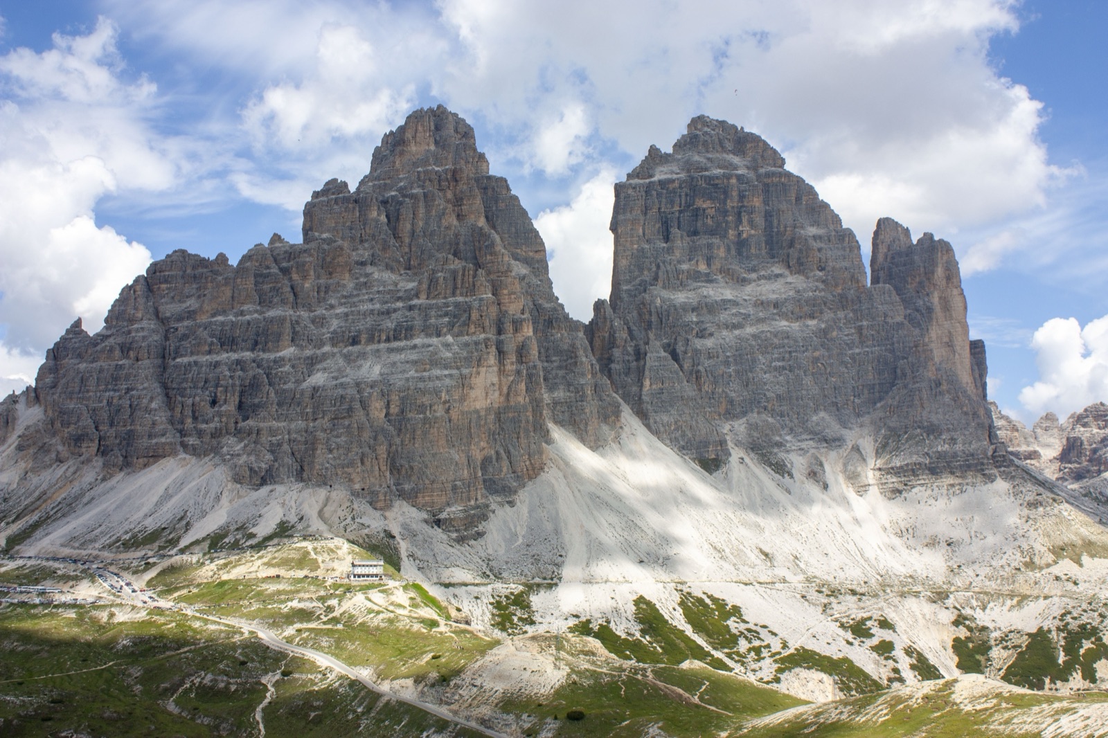
They are not part of the Tre Cime. The three towers stand to the north, and the viewpoint works because it sits between the two groups: you face the Cadini, and behind you is the south face of the Tre Cime. A dense network of trails, equipped routes and via ferratas crosses the group, from easy walks to serious mountaineering. The viewpoint walk is the easiest way in.
At a glance
- Start: Rifugio Auronzo, at 2,333 m, reached by the booked toll road, a shuttle or the bus.
- Path: CAI 117, the first part of the Sentiero Bonacossa.
- Distance: about 3.2 km there and back.
- Ascent: about 210 m.
- Time: 1 to 2 hours for the return walk; about 30–40 minutes to the saddle below the viewpoint.
- Difficulty: no technical difficulty, but narrow and exposed in places; not for those who suffer from vertigo.
- Best season: mid-June to late September, according to the same route notes.
Getting to the start: Rifugio Auronzo
Rifugio Auronzo sits at the top of a toll road on the southern side of the Tre Cime, and everything else follows from reaching it. You have three main options.
By car on the toll road
The road climbs about 6 km from near Lago d’Antorno to the hut and its large car park, and the toll point is about 3 km from Misurina. Access is by online booking only, and the toll includes parking. Our guide to getting to the Tre Cime has the 2026 prices, the season and the booking details.
By the Dolomiti Bus shuttle from Misurina
From 30 May 2026, Dolomiti Bus ran its daily Tre Cime shuttle again, linking Misurina Genzianella with Rifugio Auronzo and stopping at Lake Antorno on the way. The details for 2026:
- Price: €10 per person, a day ticket.
- Hours: after heavy demand, the operator extended the service to run continuously from 7.30 to 20.00.
- Paying: tickets cannot be bought with cash on board. Pay contactless, in the Dolomiti Bus app, or at the ticket machine at the Misurina stop.
One caveat comes from auronzo.info: in the busiest months, July and August, it advises avoiding the bus from Misurina, where long queues and waits can build, and suggests starting from Auronzo on an early departure instead.
By shuttle 444 from Dobbiaco
On the South Tyrol side, shuttle line 444 runs from Dobbiaco to Rifugio Auronzo, bookable online for both directions. It suits visitors staying in the Val Pusteria.
The walk, step by step
The route is short, but it has distinct stages, and knowing them makes the exposed part less of a surprise.
Leaving the hut
From the car park, instead of heading towards the Tre Cime loop, turn the other way. Path 117 starts right opposite Rifugio Auronzo. The first stretch drops gently on a well-marked path, with the Cadini ahead.
The fork
After a short climb the path forks. According to The WOM Travel’s route notes, both branches lead to the viewpoint, and the right-hand one is generally considered less steep. If you are unsure of your footing, take the right.
The narrow section
Beyond the fork the path narrows and cuts across a grassy slope. This is the part that needs care: the path becomes more exposed, with the slope falling away below you. It is not technically difficult, but the sense of space can unsettle people who are not used to mountain paths.
The saddle and the viewpoint
After about 30–40 minutes of walking you reach a small saddle. From there, a short detour to the left leads onto the rocky promontory that gives the famous view: rows of pale spires rising out of the Cadini’s hollows. Turn round and the south face of the Tre Cime fills the other horizon.
Return the same way. With stops for photographs, 1 to 2 hours for the round trip is realistic.
Safety on the ledge
The viewpoint’s fame, much of it from social media, means the path and the rocky promontory are busy in summer, often with people who have come for a single photograph rather than a mountain walk. A few rules keep it safe:
- Know your limits before the narrow section. If the exposure is already uncomfortable on the grassy traverse, the promontory will feel worse. Turning back at the saddle still gives you a fine view.
- Take the right-hand branch at the fork if you want the gentler option.
- Wear proper boots. The path is rocky and can be slippery when wet or when old snow lingers.
- Keep clear of the edge while you wait. Let people come off the promontory before you go out, and do not step back for a wider shot.
- Watch children closely. The walk suits children who are steady on mountain paths, not toddlers who might wander.
- Check the weather. Wet rock and wind make an exposed ledge far more serious. In cloud, the view disappears anyway.
- Respect the altitude. You start at 2,333 m; walk steadily and carry water.
None of this makes it a dangerous walk for a careful, sure-footed walker. It simply is not a stroll, and it is worth treating the narrow section with the same attention you would give any exposed mountain path.
When to go
Season
The route notes put the best period for walks in the Cadini at mid-June to late September, when the paths are usually free of snow and the huts are open. Around Auronzo, auronzo.info says the best summer hiking conditions are usually between late June and early September, and advises checking for lingering snow higher up early in the season. Access to Rifugio Auronzo depends on the toll road and the shuttles, which run only in summer and early autumn.
Time of day
The viewpoint is a popular short walk, so timing matters more than usual:
- Early morning gives the quietest path and soft light on the spires. The Misurina shuttle started from 7.30 in 2026.
- Midday is usually the busiest time on the path and on the promontory.
- Late afternoon and evening can be calmer again, with warmer light, but leave time to get down before the last shuttle.
Combining it with the Tre Cime loop
Because both walks start at Rifugio Auronzo, the viewpoint is an easy add-on to the loop around the Tre Cime. The tourist board gives 4 hours for the full loop on paths 101 and 105, so adding the viewpoint makes a full but manageable day.
- Viewpoint first: go early, before the crowds reach the promontory, then set off on the loop.
- Viewpoint last: finish the loop, then walk out to the Cadini for evening light if you are driving and not tied to a shuttle time.
If you are short of time, the viewpoint alone is a good half-day: a shuttle up, 1 to 2 hours on path 117, and time left for Lake Misurina. Our guide to the Tre Cime loop walk covers the main route.
A sample half-day from Misurina
If you are staying in Misurina or Auronzo and want the viewpoint without a full day in the mountains, this plan works without a car:
- Early morning: catch one of the first Dolomiti Bus shuttles from Misurina Genzianella (the first left at 7.30 in 2026), and pay contactless or in the app.
- On arrival: set off on path 117 straight away, before the promontory gets busy. Allow 1 to 2 hours for the walk there and back.
- Late morning: a drink at Rifugio Auronzo, or a short walk along the start of the Tre Cime path for a closer look at the southern faces.
- Midday: the shuttle back down, with a stop at Lake Antorno if you want it.
- Afternoon: the flat walk round Lake Misurina, 30–40 minutes at an easy pace, or, while it is running, the Col de Varda chairlift for a view over the lake.
What to bring
- Walking boots with a good grip. The path is rocky and narrow, and trainers give little grip when it is wet.
- Warm and windproof layers. You start at 2,333 metres and stay close to that height, and the promontory is open to the wind.
- Water and sun protection. There is little shade at this height.
- A charged phone and your booking or ticket for the road or the shuttle, and a card for contactless payment on the Dolomiti Bus.
- A wide-angle lens, if you carry a camera. The spires fill the frame from the promontory, and it is safer to change lens than to step backwards.
Photographs
The view from the promontory faces the Cadini, so the light on the spires changes through the day. Early morning and late afternoon give the most texture on the rock and the fewest people. Remember the view behind you as well: from the saddle, the south face of the Tre Cime rises above the hut you started from. On a cloudy day the spires can come and go in the mist, which can make better pictures than a clear sky, provided the path is dry.
The Sentiero Bonacossa and Rifugio Fonda Savio
Path 117 is only the first part of the Sentiero Bonacossa, a historic route that crosses the whole Cadini group between Rifugio Col de Varda and Rifugio Auronzo. This is a different undertaking from the viewpoint walk.
- Difficulty: auronzo.info says the route includes exposed and protected sections and requires experience and suitable via ferrata equipment. The WOM Travel’s notes add that the exposed sections are fitted with cables, ladders and bridges, and call for a via ferrata kit: helmet, harness and energy absorber.
- Time: about 5–6 hours for the full traverse.
- In stages: Rifugio Fonda Savio, in the middle of the group, gives the timing: the Bonacossa runs from the hut south to Col de Varda and north to Rifugio Auronzo, past old war positions, about two hours each way.
Rifugio Fonda Savio stands at 2,367 m and belongs to the XXX Ottobre section of CAI Trieste. It opens from about 15 June to 27 September. It is named after the brothers Piero, Paolo and Sergio Fonda-Savio, who died in the Second World War; their mother, Letizia Svevo, was the daughter of the writer Italo Svevo.
Only take on the Bonacossa with the right equipment and experience, or with a licensed mountain guide.
The Col de Varda chairlift
The other easy way into the Cadini starts at Lake Misurina itself. The two-seater Col de Varda chairlift climbs from Misurina to Rifugio Col de Varda, at 2,106 m, in about ten minutes.
- Season 2026: 18 June to 20 September, with the lift running from 9.00 to 16.45, extended to 17.15 from 25 July to 30 August.
- The view: Lake Misurina below, and a wide ring of mountains from the Cristallo to the Sesto Dolomites and from the Cadini to the Sorapiss and the Tofane.
- Walks from the top: Col de Varda is a starting point into the Cadini, towards Rifugio Fonda Savio on one side and Rifugio Città di Carpi on the other. The hut is also a stage on the Alta Via 4.
The chairlift does not take you to the famous viewpoint, which is on the Rifugio Auronzo side of the group. It suits a gentler day: a ride up, a walk to one of the easier huts, and a view over the lake. Check prices and dates with the tourist consortium before you go.
Lake Misurina
Most visits to the Cadini begin or end at Lake Misurina, at 1,754 m in the municipality of Auronzo di Cadore. The village and lake sit at the foot of the Cadini, with the Cristallo and the Sorapiss nearby and the Tre Cime a few kilometres away up the toll road.
- The lakeside walk: a flat loop of about 2.5 km, taking 30–40 minutes at a leisurely pace. The path is well kept and suitable for families with children and pushchairs.
- The air: Misurina has long been known for its climate and has been home to a centre specialising in the treatment of childhood asthma.
- Views: from the lakeside path you see the Cristallo group, the Cadini and the Tre Cime.
An evening walk round the lake is a good way to finish a day at the viewpoint, especially if you came up on the shuttle from Misurina.
Seeing the area on a guided trip
If you are staying in Venice without a car, a guided day trip is the practical way to see Misurina. The small-group minivan day from Venice (eight guests at most, about 10 hours) visits Cortina and the lakes of Misurina, Antorno and Auronzo, with viewpoint stops for the Tre Cime. It is a lakes-and-viewpoints day with little walking, and its description does not include the walk to the Cadini viewpoint.
If you are staying nearby, the small-group hike from Misurina takes up to 4 people up to Rifugio Auronzo and walks past the south and north faces of the Tre Cime in about 5 hours. It follows the Tre Cime rather than path 117, but it puts you at the right hut. The tours page lists both with live prices.
Nearby on this site
- Lago di Sorapis: the turquoise lake below the Sorapiss, reached from Passo Tre Croci on the road between Misurina and Cortina.
- Lago di Braies: the famous lake in the Braies valley, reached through Dobbiaco.
Frequently asked questions
How long is the walk to the Cadini di Misurina viewpoint?
About 3.2 km there and back from Rifugio Auronzo on path 117, with around 210 m of ascent. Allow 1 to 2 hours for the round trip; the saddle below the viewpoint is about 30–40 minutes from the hut.
Is the Cadini di Misurina viewpoint dangerous?
The path has no technical difficulty, but it is narrow and exposed in places, and it is not recommended for people who suffer from vertigo. Wear boots, keep back from the edge on the promontory, and avoid it in wet or icy conditions.
Where does the Cadini di Misurina trail start?
Opposite Rifugio Auronzo, at the top of the Tre Cime toll road. Path 117 heads away from the Tre Cime loop, towards the Cadini.
Can you reach the viewpoint without driving the toll road?
Yes. In 2026 the Dolomiti Bus shuttle ran from Misurina Genzianella to Rifugio Auronzo for €10 per person, and shuttle 444 runs from Dobbiaco. Book or check timetables before you go.
Does the Col de Varda chairlift go to the viewpoint?
No. It climbs from Misurina to Rifugio Col de Varda, at 2,106 m, on the other side of the group. The famous viewpoint is reached from Rifugio Auronzo.
When is the best time to visit the Cadini di Misurina?
Mid-June to late September for the paths, and early morning or late afternoon for a quieter promontory and softer light.